 |
|||||||||||||||
 |
|||||||||||||||
 |
|||||||||||||||
|
|||||||||||||||
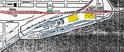
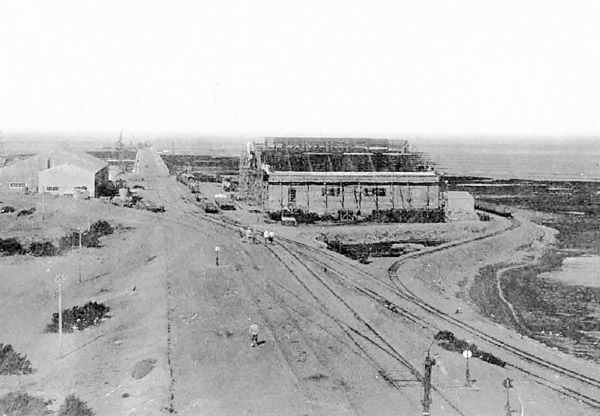
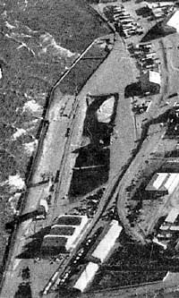
Comodoro Rivadavia pier and the 'Rada Tilly' or Punta Piedras line In the 1920s, when Comodoro Rivadavia's oil reserves were becoming increasingly important, it was decided that the town needed a much more substantial sheltered harbour rather than the existing muelles. A very solid breakwater was to be constructed and in addition a large area of land south of the breakwater was to be reclamed from the sea. Preliminary works seems to have started in 1922, with the major civil engineering taking place later in the decade, hindered by regular shortages of money and consequent design changes.. Whilst 60cm gauge track and locos were used particularly for very temporary lines, 75cm gauge equipment was also brought from the usual source at Puerto Madryn. This implies that the original network plans were already seem as less important by then. Right from the beginning, the 75cm. gauge seems to have been regarded as semi-permanent. Photographs on this page show properly built lines, rather than light contractors' tracks. In practice the system seems to have lasted for thirty years or so. The focal points of the works were the new breakwater and some land reclamation to the south-west. However, the tracks extended both north and south from there. To the north 75cm. gauge track ran to the main railway workshops at Km. 5, where a mixed gauge loco shed was constructed. To the south the line stretched out 12 or 15 kms. to a quarry, Punta Piedra and towards Rada Tilly. This was intitially the source of the land reclamation material, but the line eventually gained a passenger service. . The map below, though unclear, shows the main features of the port area. The broad gauge (in red) starts just off the map to the left. It runs due east past the station (green), before curving north to follow the coast as far as Km 5. Sidings also stretch east from the station out onto the 1928 concrete muelle. The 75cm gauge (blue) arrives from Rada Tilly at the south west corner of the map; it continues north-eastward with a number of sidings out on the reclaimed area before turning due east to proceed onto the muelle. The two largest buildings shown (yellow) are the 'galpones aduanas' or customs warehouses. The more easterly of these appears in a number of photos below.
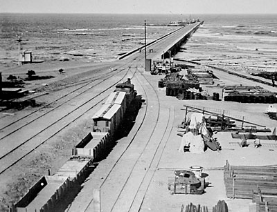
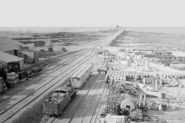
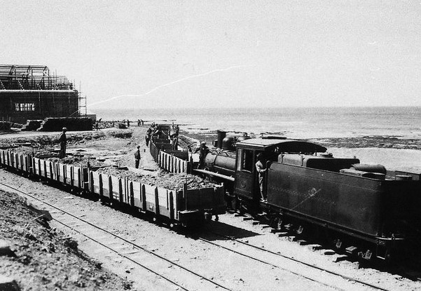
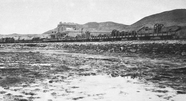
The photo below shows a Baldwin 2-8-2, presumably no. 24 or 25, at the end of a rake of 1922-built wagons in the playa de materiales at the shore end of the port. Despite the battered state of one of the wagons, this picture was taken early on before the breakwater had been completed. The absence of the hammerhead crane shows that it must only have been erected in time to assist with the construction of the outermost parts of the works. This picture is reproduced by courtesy of the Archivo General de la Nación in Buenos Aires. It was almost certainly taken from the roof of galpón 1.
An almost identical viewpoint (below) but sometime later, after the Titan crane had been erected in 1932.
This first picture shows the first of the new galpones (warehouses) under construction in about 1928. The new concrete pier stretches out left of centre, though not yet with its hammerhead crane. To the right can be seen a pair of 75cm tracks running parallel to the broad gauge, and with a loop sweeping round to the south of the new galpón. The picture may well have been taken from the top of the main station building; it is reproduced by courtesy of Miguel Fiordelli.
A similar shot but with one of the two Baldwins and a couple of rakes of plataformas (8).
A year or two later, and the galpón is complete (far left) whilst a new sea wall has been built to protect the area to be reclaimed. Far right is the station.
Land reclamation Now the reclamation starts. Here are two lines of wagons occupying sidings, and a line off to the right which is the loop mentioned above, curving around the galpón from which this picture was taken.
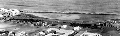
An aerial view, also from Señor Fiordelli's website, shows the reclaimed area now in use. The original galpón is at the foot of the photo and the two sidings shown above appear to remain in more permanent form.
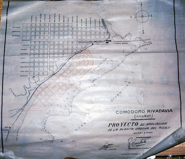
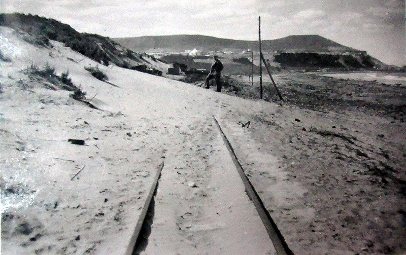
The route southward Heading southward, the route passed around the sea side of the first reclaimed area and then followed the natural coastline for about 1500m before heading slightly further inland, though still close to the coast. At this point there was an'apeadero' or halt opposite the Escuela Presidente Juan D. Perón. This may have been close to the beach still known as 'Playa 99', from the 'campamento' of the same title. After this, at about 3,500m from Comodoro Rivadavia station, there was a left hand curve bringing the line back closer to the coast. A further two kilometres took trains to an initial destination at Punta Piedras about 6.250 km from the start. In 1952 a further kilometre of track was brought into use, with a turning balloon instead of the triangle that had characterised the original terminus. There was a large hotel somewhere at this end of the line... Although some sources suggest the line actually reached Rada Tilly, this was not actually true. The headland of Punta Piedras is a major obstacle, impossible to climb over and unlikely to have justified the major earthworks needed to get around at near sea level. This map shows the line curving around the outside of the newly reclaimed land, before following the coast and later making a detour inland around 'Campamento 99'.
Another map implies that the track initially ran more directly south-west from the main FCE station. It should be noted that the reclamation proposed on this sheet never took place. This undated map shows a proposal to extend the town substantially out across the 'restinga sur' reef. Whilst the work was never undertaken to this extent, the map may give an indication of the route of the 75cm gauge railway and certainly the 'pozo 99' (well 99) gives a clear indication of how the later 'campamento 99' and 'playa 99' names may have arisen.
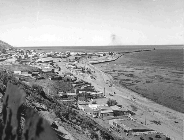
A view from the south-west shows the narrow coastal strip along which the line passed. On the original, though not perhaps on screen, the single line of narrow gauge track can be seen to follow the sea walls of the reclaimed land in the distance before turning south and paralleling the shore towards the photographer. This is a Ministerio de Obras Públicas photo from the Archivo General de la Nación in Buenos Aires.
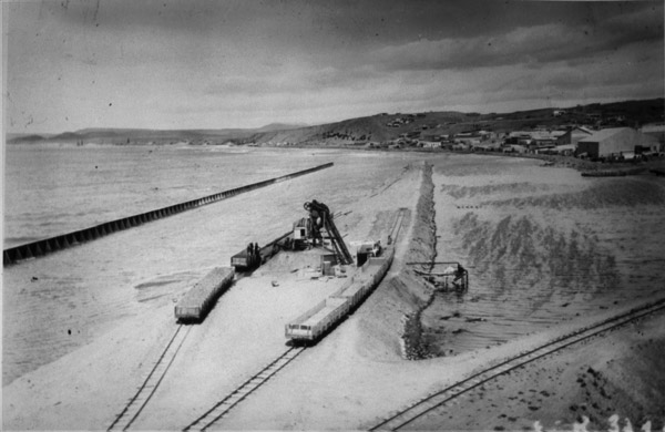
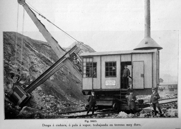
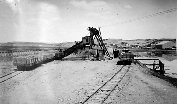
The original purpose of the 75cm gauge was to bring fill material from a site away south near Punta Piedras along the coast to the reclamation sites including the new port. The unique view below shows the big new Orenstein & Koppel steam face-shovel being transported from its landing, presumably at the Maciel muelle to be erected at the site where the fill was to be excavated (8).
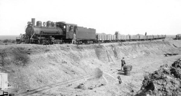
The picture below, kindly provided by Bernhard Stöckhert from an unknown source, shows BLW 2-8-2 no. 24 on a train of eight of the 4000 series plataformas, at what is presumably the source of landfill material, in 1929. A 7000 series tank wagon is far right. Another wagon is at bottom left but this may have been 60cm gauge for both gauges were used in this work. The loco is facing north with the sea in the background.
A similar scene but showing the contract's O&K steam-powered face shovel excavator in the background.
An Orenstein & Koppel steam excavator, as illustrated in the O&K / Koppel Argentina catalogue.
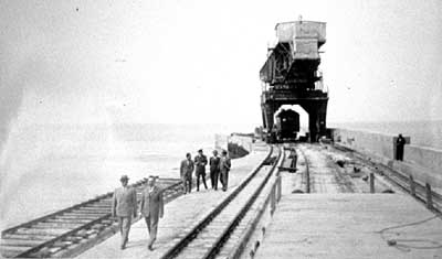
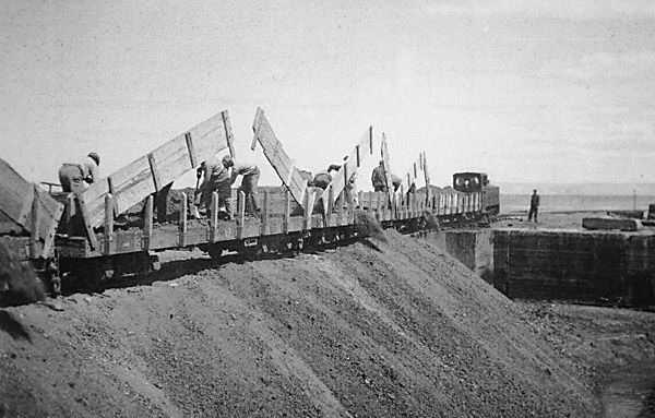
The breakwater The photo below shows the crane, and two types of track - a carefully laid double line of 75cm gauge for the crane, and two separate broad gauge lines. The photographer was standing atop a broad gauge wagon.
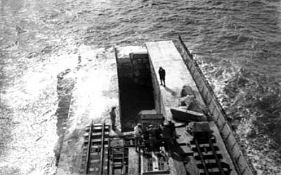
This view looking down from the crane shows how solidly built the narrow gauge tracks were - probably with heavy-duty broad gauge rails. The breakwater is still under construction and in the centre several men tip concrete (?) into the central gap. A possible 60cm gauge track section also appears bottom left. The apparent curve to the left shows that this is out at the very far end of the works.
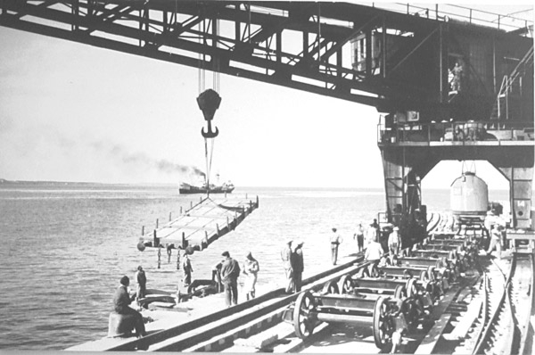
Whilst the photo below shows broad gauge wagons being unloaded by the hammerhead crane on the pier in 1943, it also shows that the 75cm track was not just for the crane's use. On the right the 75cm track clearly has a set of points in it, for use by locomotives and wagons. If these were ordinary points as they appear, then the crane cannot have had double flanged wheels as one would expect.
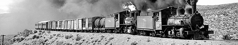
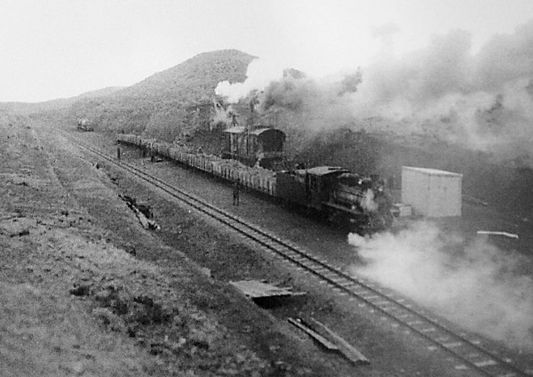
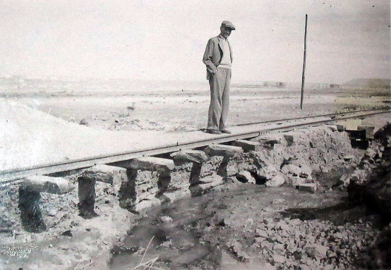
Steam locomotives The photo below shows a Baldwin, still with its bell, between Kms 4 and 5 at the northern end of the system. Note also the substantial bridge works. The photo is reported to have been taken in 1932 (2).
An unidentified 1934 source lists the Rada Tilly line as using FCP locos, but at another time there were supposed to be two 18ton locos and one 12ton loco on the 75cm gauge (1). The Baldwin 2-8-2s weighed 47tons. It is possible that a Henschel 0-6-0T (12 tonnes empty) or an 0-8-0CT (16 tonnes empty) were brought from Puerto Madryn for a while, though these are all accounted for elsewhere later on. The locos were eventually stabled at Km. 5 where there was a purpose-built joint broad gauge and 75cm shed with three roads for the narrow gauge. Interestingly, the broad gauge turntable at Comodoro Rivadavia station (which existed until fairly recently) had an inner set of 75cm gauge rails, for turning the Baldwins or possibly the railcars mentioned below. The dual gauge turntable was photographed in 1992 by Bernhard Stöckhert.. It still exists, as a monument to those killed on the 1953 accident, and can be found in the Plaza España west of the bus station.
A 1956 FC Patagonico data sheet for Comodoro Rivadavia lists Henschel 2-8-2 no. 120 as being on this line, but not either of the Baldwins mentioned above. It is possible that there was a major rethink after the 1953 accident mentioned below, and that no. 120 was brought in at that point.
A diesel
Another distant view of the diesel, this time with a single wagon way out along the dique viaducto. (7A)
Only three of this class were ever built, the other two being for Cyprus. James Waite recently took a photo of one of these others and we are grateful for his permission to display it here in order to show more clearly what the loco at Comodoro would have looked like.
Wagons The 1945 FCE lists are missing 19 plataformas, 2 'furgones cargas', 1 'cubierto' boxcar, 1 'hacienda 1 piso' livestock car, and 3 tank wagons. It is probable that most or all of these reached this railway.
This picture of workers south-west of the playa de materiales also shows a line of 75cm gauge plataformas on the left. They are identifiable as 1922 Familleureux stock from Puerto Madryn.
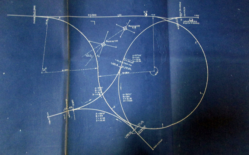
Passenger traffic At the end of 1952 the route was extended by about half a kilometre, up to the deep Arroyo Vírgenes which formed a practical boundary just before the Punta Piedras headland. A turning balloon was constructed at the new terminus, replacing a triangle which had been located at the previous railhead. A number of minor alterations to the other end of the route were proposed at the same time, though whether they were actually constructed is uncertain. They were principally intended to ease curves and to reduce conflict with other users of the main station and yard in Comodoro. It appears that the Ministerio de Obras Públicas was also trying to transfer responsibility for the line to the Military Governor of the area at around the same time, in 1954 the line was, quoted as 'pertenecía a la Dirección General de Puertos' within the responsibility of the MOP. ‘Línea Económica a Punta Piedras’ Drawings issued at that time make it clear that the FCNP had the responsibility for making any improvements necessary for passenger use, but other correspondence indicates that the FCNP did not see themselves as being the proprietors of the line. (7B) Part of the improvements included a turning facility at Punta Piedras. This blue-print shows the two alternatives considered, and the constraint produced by two oil wells. Both involved the trains having to reverse twice. Its interesting to note that the loop, round which the train will always be pulled, has a minimum radius of 100 m, while the triangle, which involves the train being propelled uses 120 m. (7C)
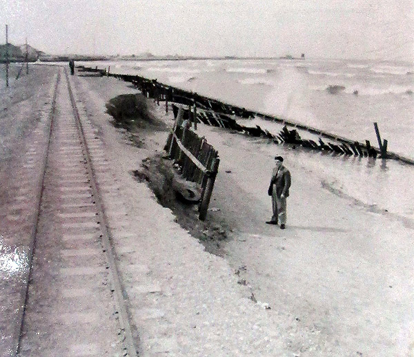
The winter of 1954 took its toll on the line, and by spring it was clear that it could not carry traffic. A report on its condition was prepared in October 1954 for “head office” in Puerto Madryn detailing, and illustrating with photographs, the embankment erosion caused by the sea, wash-outs caused by water courses coming under the adjacent road, and areas covered in wind-blown sand. While we haven't come across the decision making process which followed, we do know that in early summer (3 January 1955), the repairs to the line carried out by the firm of Marca were signed-off as satisfactory, presumably allowing services to be resumed. Here is an example of the damage done by the sea at high tide. (7B)
And here the effects of wind-blown sand. (7B)
This shows the shore line shortly after low water and the havoc to the defences that has been wrought.
Railcars and passenger coaches The photo referred to in the preceding paragraph. Note the life-buoy mounted on the furgón to the right.
There was a passenger service provided out to the terminus. In February 1953 a very serious accident occurred to a Sunday railcar returning from Punta Piedras. Running too fast downhill at 'Playa de 99' (Km. 4.250 from Comodoro Rivadavia station), it left the rails and about 25 passengers were killed and the remainder injured (3). Ricardo das Neves writes (4) that his father had gone out to Rada Tilly that Sunday, it being a very pleasant day. He missed the last coche motor back and started to walk. Rounding a corner he came upon the accident. Apparently the driver was said to have been drunk and on a passenger complaining about the speed he accelerated further rather than slowing down. The casualty list grew even longer after the coach fell as it was being righted whilst passengers were still aboard. The car was said to be a 48 seater, though actually carrying 75. Coche-motor 52 was the vehicle involved, on train no. 130. This frightening picture shows the remaining fragments of coche motor no. 52 after the accident (8). The track is presumably on the embankment to the left, ie on which the cameraman was standing. The view is towards the north-east, with the sea in the background and Cerro Chenque looming out of the haze left of centre. The car had been returning to Comodoro Rivadavia, and must thus have been travelling from right to left. Nevertheless the cow-catcher ('pilot' in US parlance) is facing right. Was the car running backwards, despite there being a turning balloon at Punta Piedras, or did it get turn around completely during the accident? The photo shows car 52 to have been one of those with rounded corners and a single windscreen, albeit with a replacement wooden cow-catcher similar to those used on locomotives. The 1956 FCP data sheet from three years after the accident lists coche motors nos. 52 and 4 as out of service - for dismantling. The same sheet lists 1st class coach 1104, and second class coaches nos. 1207 and 1210, in service. Each of these had been at Puerto Madryn in earlier years and it is again possible that they were brought to Comodoro Rivadavia as a direct result of the accident. The latter years. A recent reference seems to imply that the 1953 accident led eventually to the suspension of passenger services (5). Certainly the possibility of closure was being discussed by 1955. However, the final closure was on August 20 1958 (6). Most of the tracks were removed very quickly after that, but in 1975 there was still some 75cm track around the harbour and one or two wagons. There was no sign of any operation. Surviving relics More photographs References: Anyone interested in old photos of Comodoro Rivadavia should also visit Miguel Fiordelli's website. A number of his photos are of railway interest and almost all can be viewed in larger sizes by clicking on the thumbnail pictures. 23-2-2018 |
|||||||||||||||


Chapter 7
The 1922 75cm gauge empire


Main pages
Railcars •
Esquel route construction photos •
Com. Rivadavia to Punta Piedras •
More photos at Com. Rivadavia •
Appendices
9 Track layout photos at Ing. Jacobacci •