 |
|||||||||||||||
 |
|||||||||||||||
 |
|||||||||||||||
|
|||||||||||||||
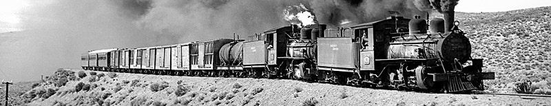
Google Earth files showing trackbed 'placemarks' and 'fly-throughs' If you have the Google Earth program you can make use of a number of 'KMZ' files which have been created to help you locate the sites and trackbeds discussed in this website. As well as 'placemarks' which identify stations, major bridges and other lineside features, there are 'fly-throughs' which enable you to fly along the old trackbeds as if in a helicopter. These can be invaluable for visualizing the landscape through which the railways ran. The following files are available, roughly organised from north to south: Bahia Blanca area on Google Earth.zip FCS a Neuquen on Google Earth.zip Linea angosta Rio Negro on Google Earth.zip FCE Patagones a Bariloche on Google Earth.zip Ing Jacobacci a Esquel on Google Earth.zip FC de Chiloe on Google Earth.zip FC salina Pen Valdes on Google Earth.zip FC Central del Chubut on Google Earth.zip FCE Com Rivadavia on Google Earth.zip FC Salina Cabo Blanco on Google Earth.zip FCE Puerto Deseado a Las Heras on Google Earth.zip Locations in the Falklands on Google Earth.zip Los ffcc de Rio Grande on Google Earth.zip South Georgia whaling stations on Google Earth.zip Right click (control-click on a Mac) on the chosen file. Save the file to your desktop and double-click to decompress it. Open the folder and drag the KMZ file onto Google Earth's Places palette. You will now find that you have placemarks for each of the main locations along the route, and in most cases paths to enable you to 'fly through' the route as if in a helicopter. Select one of these and click on the start button to commence the flight. Generally the route is clearer without the overlying vector path being checked and visible, but with the appropriate station placemarks checked. Flights or 'tours' in this website are best done with the Google Earth touring preferences set to a camera tilt angle of about 60 degrees, and a camera range of about 300m. "Fly-throughs' on long routes can be extremely tedious unless the Google Earth preferences are set to a fairly high speed. If looking for a particular location you might be better advised to click on a named placemark. However, the monotony of following the trackbed across the bare pampa for hundreds of miles does at least give a clear impression of the problems of making such a railway pay its way. 20-2-11 |
|||||||||||||||
Main pages
Websites •
Chapter 14
References, resources &
thanks for help