Short jetty and other tracks, in Stanley and out on the stations
The use of short lengths of railway line was almost universal on jetties, in the islands as elsewhere in the region. Rail tracks had the big advantage of minimal danger of falling off the sides of a pier, and very little disadvantage when the loads would be transhipped anyway at the pierhead or had come from only a few yards away in the case of wool bales and the like.
It may well be that wholesalers such as the Falkland Islands Company in years gone by carried rails and trolleys as a regular line, in the same way that they would later stock parts for tractors or other vehicles. However, if that was the case why can such a variety of gauges be found. 2', 2' 6", 3' and 3' 6" can each be encountered around the islands?
Jetties at Stanley, from east to west:
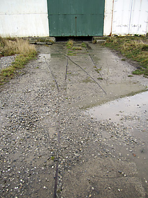
The Falkland Islands Company jetty
Gauge 2' 6". Most track removed, but a small amount remains within one of the sheds.
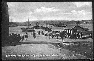
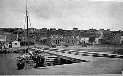
The public pier
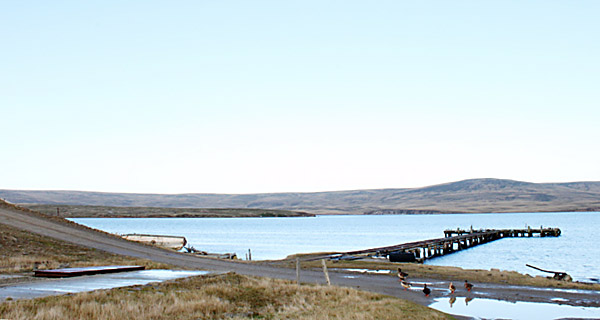
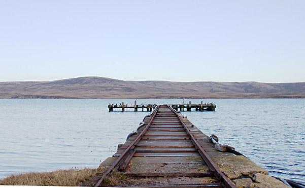
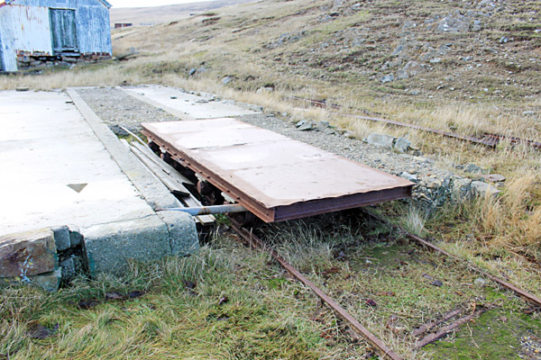
This bore tracks for many years. Initially a single line of rails ran out along the fixed portion and onto a wooden span which led to a floating pontoon. One postcard shows a small wagon with spoked wheels (1). The pier was later rebuilt and enlarged. Further postcards show that the new construction had two lines of track of about 2' gauge, and a single line across the wider sea end perhaps accessed by wagon turntables. Interestingly the track at the landward end seems to carry on up the hill for some distance.
The majority of the present jetty is a relatively recent replacement, and there are now no signs of the tracks mentioned above even on the outer end which appears to be rather older than the rest.
1 A view from the landward end. A single track comes off the pier, beneath the wheels of the horse-drawn cart, and may well continue off to the right.
2 A side view from the east.
3 A view from the seaward end, showing the double line of tracks merging back into one at the near end.
And from the opposite end...
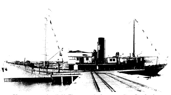
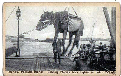
4 At the far end of the pier a single line of rails ran transversely, presumably from a wagon turntable. However, it seems unlikely that the horse illustrated below would have travelled by rail!
The Charles Cooper and Actaeon jetty
This jetty, now almost entirely demolished, carried a single railway track, of 2' 6" gauge or wider, as seen in an old photograph (6)
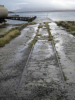
The government jetty, in the dockyard
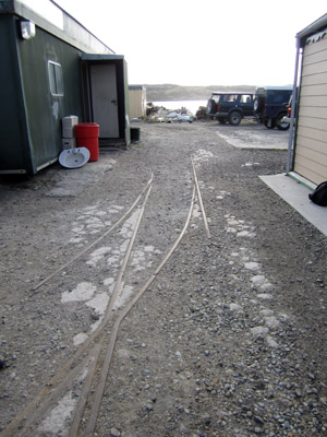
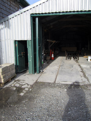
Gauge 2' 6". The pier has been dismantled, but track, including a pair of points, survives near its head and within one of the sheds.
The 'Jhelum' pier
Keith Heathman, who dismantled this pier in the early 1990s, stated that he had seen no sign of any rails.
Jetties at stations out in the camp
The majority of Falklands farms had short hand-worked railway tracks to transfer wool from the shearing shed to the jetty. Such locations included Chartres, Darwin, Fitzroy, Fox Bay, Hill Cove, North Arm, Port Stephens, Port San Carlos, Salvador and San Carlos, whilst Goose Green and Port Howard had larger systems linked to their meat canning plants as well as to the shearing sheds. All known information about each of these sites is set out below in alphabetical order.
It should be noted that the development of better roads in recent years, particularly across East Falkland, has meant that many of these jetties are now disused.
Chartres
Darwin
Jetty no longer exists, as in later years most traffic went via the nearby Goose Green jetty. Some old rails survived close to the site of the Darwin jetty, suggesting that it had possessed a railway line.
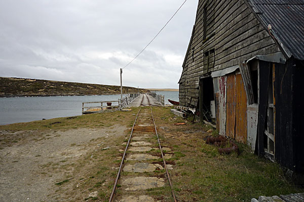
Fitzroy
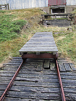
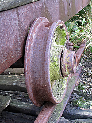
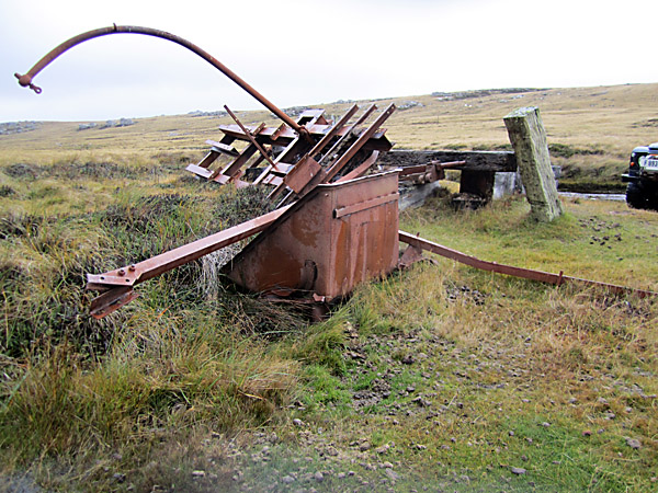
Gauge nominally 3' 6", actually measured as 3' 5" but with loose rails and a wagon whose wheels were so worn as to be almost double-flanged. A single dead-straight track from the shearing shed bale store door across the 150 yard bridge to the head of the very short jetty. One home-made flat wagon of extremely long wheelbase. All still in existence May 2011.
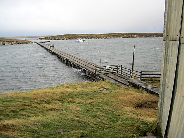
The first photo shows the railway track stretching from the wool store, right, across the shallow inlet for approximately 120 yards to the head of the short deep water jetty which ticks out to the right. The pictures below show the long home-made trolley standing beneath the doors of the wool store, and a very well worn wheel.
Fox Bay
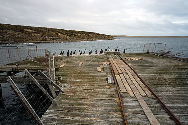
Goose Green
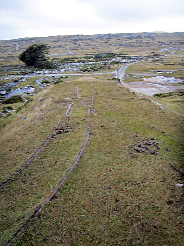
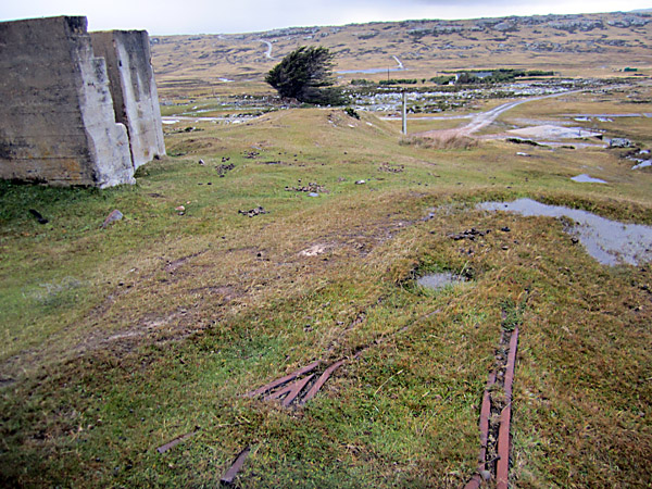
Gauge 3'. This was a large system.. In fact a previous manager of the station has written that, "In the early 1900s the shearing shed and try works had an extensive circuit of rails connecting all work places and warehouses to the jetty" (9). The canning plant burnt down in the late 1950s; the rail system later fell into disuse and was mostly removed. Some tracks near the surviving jetty were recently concreted over but short lengths of track, including one pair of points, outside a transit shed can still be seen in May 2011.
A view of Goose Green from the higher ground to the north-west shows the area once served by the railway tracks. Far right, with red and green roofs, is the shearing shed, whilst immediately left of this, in the far distance, was the canning plant. The main track seems to have run from the shearing shed to one of the transit sheds (just left of the community hall with its spire in the middle of the photo) and then further left to the two jetties. Other track ran past a second transit shed (just right of the community hall) and over to the canning plant.
A short length of track, including a set of points, remains outside one of the transit sheds, whilst another short length is close by at the head of the present jetty.
Hill Cove
North Arm
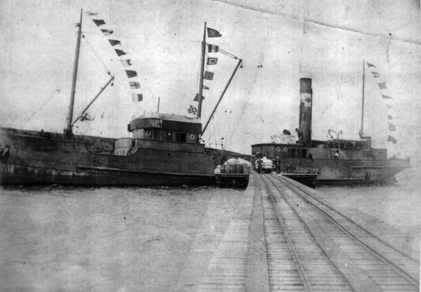
Fernando Coronato of Puerto Madryn has forwarded the following pictures showing a wider-gauged track onto the pier here. This is in the Lafonia area in the south of East Falkland (5).
At first glance the track looks like any other hand-worked pier line, but closer examination, particularly of the second photo below, suggests that the gauge was probably nearer three foot than two.
The topography in the background identifies this as the North Arm jetty in an earlier era.
Pebble Island
Port Howard
Had a tallow-producing or 'trying' plant. This later became a meat station where the sheep were slaughtered and dried before being frozen on board ship. There were no freezer factories on the island like those in South America until the construction of the Colonial Development Corporation plant at Ajax Bay in the early 1950s.
Port Stephens
Had a tallow-producing or 'trying' plant.
Port San Carlos
Salvador
San Carlos
This station had a meat-canning plant at one point, but the remaining track appears to be just a straight length from a loading platform out along a straight jetty. The gauge may well be 3' 6" or something close to it, and the sole wagon seems to be a home-made affair rather like that at Fiztroy.
These photos from early 2011, were very kindly provided by Flight Lieutenant H Griffiths of the RAF.
(4).
Other railway systems
Stanley Improvement Works
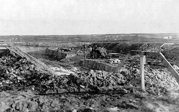
In the 1920s a number of improvements were made around Stanley, including a new reservoir and better roads. The engineer in charge was one George Roberts, from whose photographic collection the following three pictures are taken (10).
The first of Mr. Roberts' photos shows the excavation of the new reservoir in May 1925. A loaded skip wagon is in the centre of the picture with track leading off to the right behind the profile board.
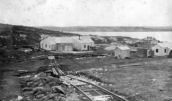
The improvement works depot had a quarry at its back, possibly from a stone run rather than excavating from the solid. This April 1925 shot appears to show a rope-worked incline running down into the depot. The final photo was taken at the right hand end of the main building, suggesting that the rail system extended at least that far. It would appear that the gauge was 2'.
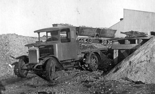
The third photo shows road metal being loaded onto an early lorry, from skip wagons at the far end of the main building shown in the picure above. The photo was dated in July 1926.
'Quarries' at Moody Brook
It should be noted that these locations worked loose material found in 'stone runs' rather than solid rock quarried from strata in situ.
1 Above Moody Valley Farm, just south of the head of Stanley harbour.
2' 6", and 2' gauge. Including a balanced incline built on mass concrete piers across a stream, from the stone run down to the crusher site. More recent tracks are of 2' gauge, with several skip wagons by Allens of Tipton surviving. However, at the crusher, there are surviving older tracks of 2' 6" gauge. This location may have been disused by the early 1960s.
The photo above shows a line of mass concrete piers which carried a railway track from a stone run on the hillside above across the stream in the foreground and down to a crusher below. Although the piers are only wide enough for a single narrow gauge track the incline was apparently worked by a loaded downhill wagon pulling up an empty uphill wagon, so there must have been a passing loop or other device to permit the wagons to pass.
These two very similar views show the site of the stone crusher on the hillside above Moody Brook. The upper photo illustrates a 2' gauge headshunt on an stub embankment just below the crusher. The lower picture, only a few yards away, shows a set of 2' 6" gauge points, perhaps from an earlier system. In the upper of the two illustrations can be seen a white building in the top right hand corner. This is the erstwhile water treatment plant at the head of the road from Stanley, thus enabling the location to be pinpointed more accurately.
2 A mile or so further west, along the old north camp road
2' gauge, across the valley floor from a stone run on the south side to a crusher adjacent to the road. A skip wagon survives half buried next to the crusher site. This location was worked somewhat later than the other site, possibly until the 1970s. Latterly traction was provided by a converted Land-Rover on rail wheels (7).
The remains of the stone crusher (which puzzlingly seems to incorporate a ship's davit!), and a single complete skip wagon of 2' gauge.
The Camber / Navy Point
As well as the Camber railway using 2' gauge, there may well have been a network of 2' 6" gauge tracks here, judging by a number of skip wagons lying here amongst the derelict buildings and other scrap metal. It is worth noting that one of the principal users of 2' 6" gauge railways in the United Kingdom has been the Royal Navy, and that this location was a naval depot is unlikely to be a coincidence. The site includes a substantial quarry, whose products form the stone walls of the Camber harbour and of the nearby house and pumping station. The latter is intact and still contains a vertical boiler and Tangye steam pumping engines, last used in 1967.
The 2' 6" gauge skip wagons remaining at the Camber, and a number rescued with the Camber railway locos and placed in containers elsewhere in Stanley for safe-keeping, are of fairly archaic construction and look remarkably similar to the wagon seen in a 1915 photo of a Camber railway loco. This raises the possibility that some of the 2' gauge 1915 skips were regauged for use on 2' 6" tracks after the demise of the main-line to Moody Brook. This would have been relatively easy given the inside bearings of the 1915 skips.
Try-works east of Stanley, near 'The Gardens'.
This was mentioned in a book about the Stanley waterfront, but the precise location has not been identified and there would appear to be no obvious remains. Such meat-boiling and tallow-producing factories elsewhere in the islands commonly used rail tracks, but whether this was the case here is unknown.
Eliza Cove, south of Stanley
At one time there was a stone crusher here, using stone gathered from the beach, and a short rail system. The Stanley rubbish dump is nowadays in this area but the precise location of the crusher is in a minefield and is thus not accessible (8).
Storage bunkers at the Canache
2' gauge, possibly of WW2 vintage. At the south end of the bailey bridge over the Canache, there are two concrete block warehouses partially buried in soil. Nowadays one of them is used as a fire brigade training site. Each warehouse has a 2' gauge track down the centre, and as the space between the warehouses lies immediately at the landward end of a narrow jetty, there may well have been a wagon turntable and a track onto the jetty itself or its predecessor.
Cape Pembroke lighthouse
Another old postcard (2).shows this location. There appears to be a short track, mounted partly on piers, to bring supplies up from a scotch derrick mounted at the shore. Whilst the base of the derrick still exists, an examination of the site in May 2011 found no traces of any railway track.
New Island whaling station
A short-lived whaling station constructed here by Christian Salvesen is mentioned on the whaling station page. Photos have been seen showing surviving boilers and a stationary steam engine but whether any remnants of the sloping rail tracks down to the jetty still remain is unknown.
Albemarle sealing stations
There were also two sealing stations at Albemarle in the southeast of West Falkland. The remains of these still lie there.
References:
1 Postcards of the Falkland Islands, A Catalogue 1900 - 1950. 1985. H. and F. Heyburn. Picton Publishing, Chippenham, UK. Page 50.
2 1988 Supplement to Postcards of the Falkland Islands, A Catalogue 1900 - 1950. 1989. H. and F. Heyburn. Picton Publishing, Chippenham, UK. Page 42.
3 These placenames were cited in The Falkland Islands Today, 1952, by the Revd. Forrest McWhan. Stirling Tract Enterprise, Stirling, Scotland.
4 Thanks to Tim Cotter of the Falkland Islands Development Corporation for details of locations with surviving remains.
5 Photos kindly provided by Señor Fernando Coronato of Puerto Madryn, 2009.
6 Photo reproduced in A guide to the Stanley Harbour Maritime History Trail, by Graham Bound, published by Falkland Islands Tourism 1990.
7 Conversations with Johnny Macaskill and Keith Heathman, 2011.
8 Conversation with Richie Anderson 2011.
9 Private communication from Eric Goss, 2011.
10 Photos reproduced by kind permission of the Falkland Islands Museum & National Trust.
29-8-11
|