 |
|||||||||||||||
 |
|||||||||||||||
 |
|||||||||||||||
|
|||||||||||||||
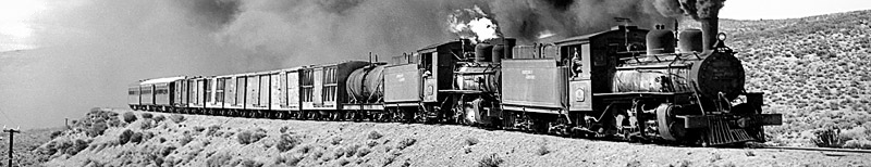
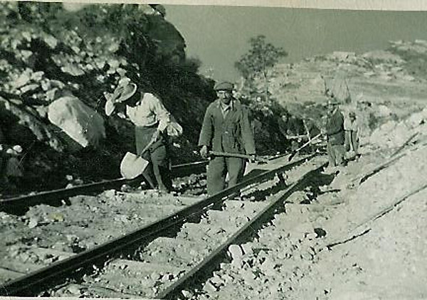
Other mines Apart from coal workings and gold dredging there have been a number of other mines in Patagonia, though many of them have been very shortlived or so small as to make do with hand-worked lines or 'ferrocarriles de sangre’. Those known are listed below, divided up by province: Chiloé (part of Chilean Region X, Los Lagos) Aisen (Chilean Region Xl) 2 Further south there were a number of mine sites around Lago Buenos Aires. The Cia. Minera Tamaya was the holding company for a variety of individual mine businesses (2). Zinc and lead at a rate of 10,000 tons per year came from the Cia. Minera Aisén’s mine at Puerto Cristal, and was carried east across the frontier to the Puerto Deseado railway for onward shipment. A small amount of silver also came out of this site. Copper was worked at Las Chivas, and at Guadal the Mina Escondida (or Mina Cerro Guadal) at one time employed 150 workers. This last site was run by the Cia. Minera del Plomo so presumably lead was the main product. It was abandoned in the 1970s but 50 or 60 cm gauge tracks were still visible in 1994, though no wagons remained (3). Of these the Puerto Cristal site is only one to have thrown up any hard evidence about railway usage, and what existed was indeed spectacular. The mine was 900m. (about 2500 ft) above the level of Lago General Carrera (Lago Buenos Aires to Argentine readers), so a two stage incline was built to lower the wagons of lead and other ores to the processing plant and the dock at the lake side. The gauge is uncertain but may have been 60cm. The photo that first alerted us to the scale of the Puerto Cristal operation (12). This view looking down the lower incline also shows some of the buildings at the bottom on the lake shore. It looks as though the system may have involved double track balanced inclines, though the fourth rail is not visible. The gauge appears to be 60cm, or possibly 75cm.
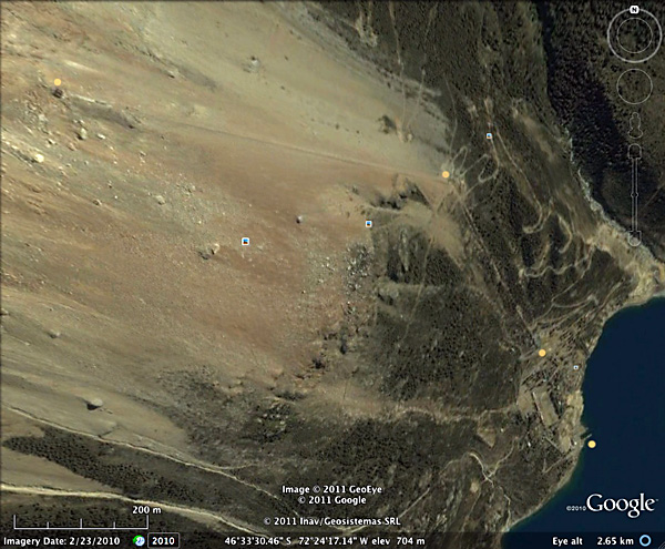
Once aware that there was a incline, Google Earth satellite photos can be searched for obvious straight lines. In this case the lakeside dock can be seen at bottom right, together with the remains of sizable buildings. Yellow dots have been added to indicate main points on the incline system, which first rises 350m north-westward to an intermediate winding house before turning west-north-west and rising another 400m to the mine entrance. Each section is about 1 km long in plan, though appearing to be different at this scale because Google Earth's terrain mapping is attempting to show the higher ground to the left in 3D.
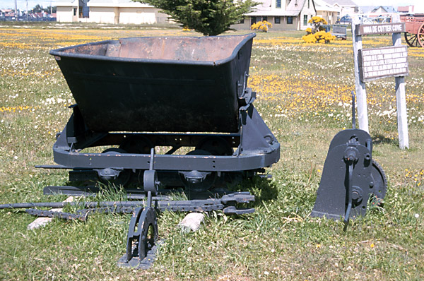
The mining company seems to have operated a steamer on the lake; possibly it may still there. As mentioned above the product was exported across the border to Argentina, for onward travel via the Las Heras to Puerto Deseado railway and eventual processing in Comodoro Rivadavia. In later years on the other hand it travelled westward by lorry to Chacabuco. 3 The Cia. Minera El Toro held the rights to mineral deposits of various kinds at Bahía Murta, Cerro Colorado, Lago Negro and at Río Muller and Río Fachinal but whether they were ever exploited is uncertain. The principal problem for most of these locations was the lack of a reliable route out to Puerto Aisén or some other Chilean port. This must have been a major factor in the lack of success of some of these workings. It is only recently that a proper metalled highway has been extended southwards. 4 For similar reasons, in the 1920s, the presence of sizable oil shale deposits in the President Ibánez Bay area of Lago Buenos Aires prompted proposals for a 300km railway to link directly to Puerto Aisen (4). Nothing came of this. Magallanes (Chilean Region Xll) 6 Cutter Cove, on the west side of Peninsula Brunswick in Magallanes. Copper ore was discovered in 1904 and worked for a while by the Sociedad de Minas de Cobre de Cutter Cove using miners from Spain. 129 people were stated to be living on site in 1906 (5). However, the poor exchange rate was blamed for its unprofitability and it had ceased operations by 1911 (6). It certainly had an internal railway system of a reasonable size. Messrs. Orenstein & Koppel of Berlin built two 50hp 0-4-0Ts for 750mm gauge in 1904 to the order of the 'Mines de Cuivre de Magellanes' and to be delivered via Punta Arenas. These were almost certainly for this railway, and help us to define the gauge as well as to visualise a substantial system. The photo below shows a railway track at Cutter Cove in the first years of the 20th century.
The deposits were explored again in the 1960s and '70s, this time using 60cm gauge equipment..
The skip wagon below is now exhibited at the Museo del Recuerdo on the outskirts of Punta Arenas.
The story of Cutter Cove may yet be not over. On 17 March 2014 the Government of Magallanes, in the shape of a decree (084/2014), issued by José Luis Riffo Fideli, the regional director of the Servicio de Evaluación Ambiental, in connection with proposed mineral exploration at Cutter Cove by the firm Redhill Magallanes, showed that where was still a mineral interest in the area. This followed a visit of a municipal official on 6, 7 and 8 May 2013 accompanying Dickson Consultores who were making a report for Redhill.
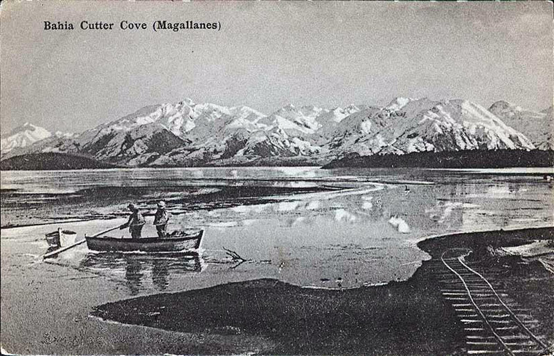
No place is too remote as to be not worthy of a commercial post card as can be seen below. Just quite why there was track wiggling down the beach is no clearer than what the two men are doing in the boat in the icy water. The post card was for sale on eBay in the USA.
7 Yendegaia on the Beagle Channel. A copper deposit was explored briefly around 1905-7 but reports were unfavourable and the site was abandoned (7). Río Negro
This clearly shows a large number of four-wheeled skip wagons presumably of 60cm gauge. The skip chassis mounted with a tank or drum was apparently to take water up to the workers at the quarries.
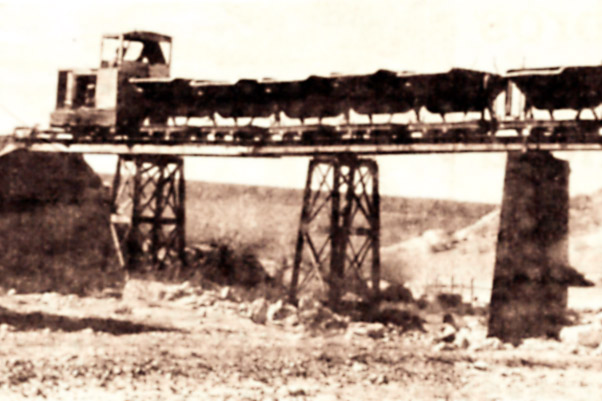
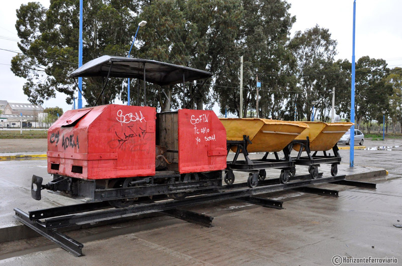
The diesel loco appears to be taking a train of empties up the line. The viaduct appears to be within the quarry workings. Señor Garay reports that a diesel loco was used to haul the empty skips up the line, and that the full ones then returned by gravity, the factory being 200 m lower. Presumably the wagons ran down with the loco providing braking power, rather than unaccompanied á la Ffestiniog. The track was apparently lifted about 1970. The Horizonte Ferroviario bogspot posted a number of photographs of Padre Alejandro Steffenelli station in 2014 which include a small diesel and a couple of skips. Apparently the station was linked by a decauville line built in 1913 to the gypsum quarry to the processing plant. The firm was the Compañía Corral Minera, Industrial y Comercial which was started in 1899. The location of the quarry is not yet established, though it is about 15 km from General Roca. There is no evidence on Google of the decauville in the station yard, though it is still in use for loading it.
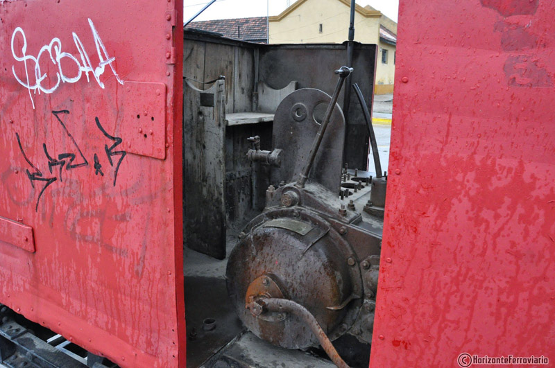
The loco is an Austro-Daimler, probably an SL12A petrol-electric, built in Austria, most likely in the late 1920s. Klaus Komischke points out that these are very rare in Europe let alone in South America. The roof apparently folds down to protect the interior and to prevent unauthorised use.
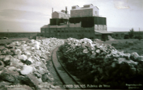
9 A little further north-west there was another gypsum works at Cinco Saltos, which clearly had a loco worked narrow gauge railway in a postcard photo displayed in San Antonio Oeste town museum. This plant was operated by the firm of Castiglione & Pes, and today is a bentonite mill. The photo is displayed below. A steam loco of some kind is in the extreme right background.
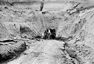
10 Mina Sierra Grande, on the coast between San Antonio and Puerto Madryn. Sierra Grande has extensive iron ore deposits, discovered in 1944. The existence of this resource was cited in various state railways reports in the1950s as an added reason to construct the first part of the FC Trans-Patagonico southward from San Antonio. From 1969 until 1991 the area was worked by a state company, Hipasam SA. The mine apparently has 96 km of tunnels accessing large caverns (8). There is a small mining museum at Sierra Grande and visitors can explore some of the tunnels during guided tours. Chubut 12 Mina Ferrocarrilera, near Senguer. Galena, Gold and Silver. NB The mine is named after the Cia. Ferrocarrilera y Petróleo, owned by a group of Argentine railway companies, not for any direct railway connection on site. 13 Mina Huemules. Near Futaleufú. Quartz with gold and silver pyrites. 14 Mina Mari Mari, at Paso de Indios. Barites. The mineral museum in Comodoro Rivadavia suggests that none of these above four Chubut mines has ever been worked in a sustained commercial fashion. 15 Mina Parana. Chubut. Kaolin. This is another name for the kaolin deposits worked on the upper length of the FCCC. There were 75cm branches to these workings. One photo has been seen showing four wheeled skip wagons within the workings, probably on 60cm gauge (11). 16 The Salina Grande on Península Valdés has its own page elsewhere in this chapter. The following photo showing a horse and wagon outside an adit somewhere, was found in the Archivo General de la Nación in Buenos Aires, by David Sinclair and Sergio Barral (9). Its location is unknown though it seems likely to have been in Chubut somewhere, possibly near Comodoro Rivadavia.
Santa Cruz Tierra del Fuego South Atlantic Islands References: 27-3-2021 |
|||||||||||||||
Chapter 13
A variety of industrial railways